Professor Hisham Al-Azmi, an expert in remote sensing and earth systems science at Chapman University in the United States, reviewed the risks surrounding the Grand Ethiopian Renaissance Dam due to the varying subsidence of the earth's crust beneath the dam. During his speech at the fifth general session of the Fourth Cairo Water Week, Al-Azmi mentioned that a research team, including Dr. Mohamed Abdel Ati, Minister of Water Resources and Irrigation, produced an important study using radar technology via satellites to monitor vertical and horizontal movement of the earth's crust in the area where the dam is being built, according to Masrawy.
The expert confirmed that the Renaissance Dam project consists of two structures: the main concrete dam and another rocky structure known as the saddle dam, which significantly increased storage capacity behind the concrete dam and could be very dangerous to the earth's crust in the surrounding area, which suffers from cracks and fissures. He pointed out that the synthetic aperture radar (SAR) technology has provided us with numerous and varied pieces of information regarding the variation in land subsidence and uplift rates in the area of the dam’s construction from 2017 to 2021.
He continued, "There is a clear difference in the land elevation between the eastern and western sectors of the dam, as well as differences in the geological characteristics in the area of the dam's construction, in addition to weak areas beneath the current structure of the dam."
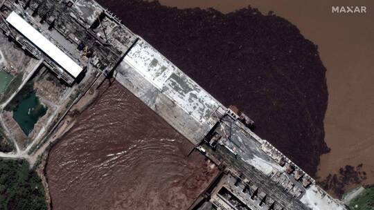
During the session, Al-Azmi presented satellite images showing continuous vertical subsidence at one point of the dam, coinciding with the first filling, which was evidenced by the appearance of waves in the water at the edge of the concrete body of the dam, along with radar data showing differing water movement in that area.
Al-Azmi indicated that the results of this study pertain solely to the condition of the land and its movement beneath the bodies of the Renaissance Dam and the saddle dam, without touching on the engineering structures not covered by the study or the specialization of those conducting it.
The study also observed water contamination in the Lake of the Renaissance Dam due to vegetation, which was evidenced by satellite images through radar technology capable of penetrating the ground and providing varied and diverse results.


