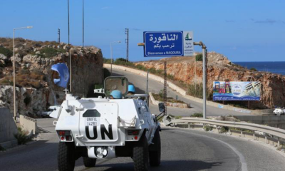


Last week, Minister of Public Works in the caretaker government Ali Hamieh visited the southern border, raising the issue of the railway tunnel at Ras al-Nakoura on the Lebanese-Palestinian border, which Israel sealed with concrete and a metal gate since its withdrawal in 2000. This tunnel is used for tourism purposes, and his visit has reignited the discussion about the land borders, on which Lebanon has reservations at many points. It has also brought back to mind the fate of Shebaa Farms and its identity—whether it is Lebanese or Syrian. Retired Brigadier General Anton Murad confirms to "al-Markaziya" that "there is no doubt that Shebaa Farms is Lebanese, but there are many points that affirm its Lebanese identity and many points that weaken Lebanon's claim.
The documents that support Lebanon and confirm that Shebaa Farms belongs to Lebanon include, but are not limited to: firstly, the documents of Pierre Bart, dated 12/10/1937, where he wrote a report and drew a map indicating the correct borders. The most important aspect of his report states, 'From the border point near the town of Al-Abbasiyah, the border should deviate southward to include the Nakhila farm and then take a northeastern direction, passing 700-800 meters north of the Maghar Shebaa, and connects east of this farm to Wadi al-Asal, then follows it along its course until it finally reaches the summit of Mount Hermon.' Secondly, the report of Captain May and First Lieutenant Lacroix, dated 15/6/1938, where they discussed the Marj al-Mun pond located within Syrian territory, 1500 meters from Wadi al-Asal, which forms the border line between Lebanon and Syria. Thirdly, a letter from the mayor of Shebaa dated February 21, 1944, sent to the then-President of the Republic, requesting intervention because the Syrians were encroaching on Lebanese land, indicating that the Maghar Shebaa ends in the flat area near the road connecting Lebanon to the Banyas area, that is, between Marjeyoun and Quneitra. He requests the Lebanese authorities' intervention. Fourthly, a committee was formed from a Lebanese judge, Rafiq Ghazawi, and a Syrian counterpart, Adnan al-Khatib, on 27/3/1946, who created a map that defined the boundaries of Maghar Shebaa, thus solidifying the boundaries of Shebaa Farms claimed by Lebanon as delineated in the Ghazawi and Khatib map, bounded to Wadi al-Asal according to the report of Lacroix and Pierre Bart.'
Murad adds: 'We are discussing old documents, not new, that confirm that Shebaa Farms is Lebanese, but the factors that negatively impact Lebanon's claim and weaken its position are: First, the existence of official Lebanese maps from 1920 that place Shebaa Farms outside Lebanese territory. When Pierre Bart offered his map and Lacroix submitted his report, Lebanon did not correct the map but continued to rely on the erroneous official map within Lebanon and implicitly within the military institution. Second, in 2000, when Lebanon sought to rectify the situation and produce a new map, an erroneous map was drawn placing the entire Ghajar area within Lebanon, although Lebanon was requesting the United Nations for half the area of Ghajar since the border passes through its middle; hence the erroneous map persists and is still used today in official circles, including the military institution. Third, there are no records in the Lebanese property registries in the south, as evidenced by the response of the Secretary of the Property Registry in the south, Nizar Ibrahim, on 6/7/1994, when asked about documents related to Shebaa Farms, and the answer was that there were no documents. Fourth, and most importantly, there exists a decision from the Public Prosecution dated March 14, 1956, declaring that the Public Prosecution in the south considers Shebaa Farms to be Syrian land, prompting the responsible Lebanese authorities to order the judicial authorities to cease executing any previously issued judgments regarding Shebaa Farms. Fifth, the Lebanese state has recently discovered that it does not possess a file on Shebaa Farms, although the issue of the farms has been raised since 1920, and a committee was formed in 2005 under the chairmanship of Ambassador Mohammad Shatah, which requested the formation of a file for Shebaa Farms. Sixth, and finally, the political division regarding the identity of these farms, with some Lebanese still not recognizing their Lebanese character while others assert that they are Lebanese.'
Murad concludes: 'Shebaa Farms is Lebanese, but Lebanon is still neglecting its duties, even though the easiest way to determine its identity—since it is neither Israeli nor definitively Lebanese or Syrian—and given that Syria unofficially acknowledges that these farms are Lebanese—is for the Lebanese team to approach their Syrian brother and request a formal identification of these farms and to issue a map on the matter and notify the United Nations. Yet this does not happen because there is a faction that accuses anyone discussing Shebaa Farms of treachery. Therefore, this is the safest path, and everything else amounts to posturing and exaggerations that will not lead to the liberation of Shebaa Farms.'