


Under the title "Warning of Catastrophe if Completed: Discoverer of the Renaissance Dam’s Subsidence Unveils Surprises," Al Arabiya reported on a recent scientific study involving Egyptian and American experts, including Dr. Mohamed Abdel-Aty, the Egyptian Minister of Water Resources, as well as experts from American and Egyptian universities and international organizations. The study revealed the existence of ground subsidence at the site of Ethiopia's Renaissance Dam, with numerous images indicating significant breaches in the dam's safety factors, confirming that it is not safe at all. The study analyzed 109 images and scenes from December 2016 to July 2021 using radar imaging technology, all indicating various directional displacements and movements in sections of both the main concrete dam and the auxiliary embankment dam, signaling a serious risk.
According to the study, "Data analysis at the dam site clearly reveals asymmetric subsidence at the edges of the main dam, particularly on the western side, where varying displacements were recorded ranging from 10 mm to 90 mm at the top of the dam." It noted that the dam was being filled rapidly without any prior study or data analysis, which adversely affects the dam’s structural integrity and hydrologically impacts the Blue Nile Basin. It also disclosed that there were uneven vertical displacements in different sections of both dams.
The study highlighted excessive and uneven inflows on both the eastern and western sides of the Renaissance Dam, which experts involved in the study believe are behind Ethiopia's halt of the second filling, settling for what was stored, which amounts to 5 billion cubic meters for the first filling and 3 billion for the second.
In statements to Al Arabiya and Al Hadath, Dr. Hisham El-Masri, a professor of remote sensing and earth system sciences at the University of Champaign in the U.S. and the head of the research team that conducted the study, explained that the study was based on the safety of the dam, which Egypt and Sudan requested from the Ethiopian authorities, but faced Ethiopian obfuscation and neglect. Moreover, inquiries were made regarding the storage process, how it is conducted, and what studies had been performed on the dam's safety should the water reach the quantity declared by Ethiopia since such a quantity, if not managed safely, poses an existential threat to both Egypt and Sudan.
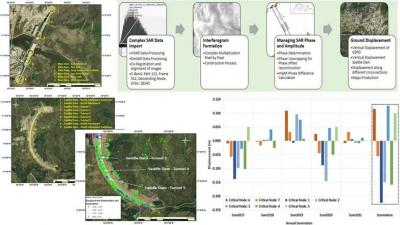
He pointed out that due to the dam's danger and the existing obfuscation from Ethiopia, it was necessary to monitor everything related to the dam's safety. Thus, satellite images and remote sensing techniques were employed to investigate any possible defects in the dam's structure. The study utilized radar beams directed from the satellite toward the target, returning to the satellite for data analysis.
Dr. El-Masri noted that radar images revealed soil movements around the Renaissance Dam and insights into what was happening with the concrete dam and the embankment dam, indicating the concrete dam alone cannot handle more than 18 billion cubic meters of water. Ethiopia planned to store the remaining quantity in a reservoir alongside the embankment dam, which is 6 kilometers long, to reach a total storage capacity of 74 billion cubic meters.
He further stated that when announcing the start of the second filling, Ethiopia officially communicated to Egypt and Sudan its intention to store more than 13 billion cubic meters, which did not occur, raising suspicions about the halt of the second filling. There was a need to investigate the cause and the hidden reasons behind Ethiopia's actions.
The research team did not monitor the conditions in the middle section of the concrete dam since construction was not complete, but it was crucial to observe issues at the sides built years ago. Radar images revealed vertical displacements on both the eastern and western sides of the dam since 2016, and at the onset of the first filling, non-uniform vertical displacements were detected, indicating unequal subsidence on both sides, with one side sinking more than the other and struggling at the expense of the other side.
Dr. El-Masri emphasized that this situation requires an explanation from Ethiopian authorities, questioning whether they discovered this subsidence at the start of the second filling and decided to halt the filling, or if another reason exists. Concerning the embankment dam, he asserted that to achieve a storage capacity of 74 billion cubic meters, water would need to begin flowing to this dam, which has not happened yet, signifying the concrete dam has not been filled to the capacity necessary for water to reach the embankment dam.
If the water has not reached the embankment dam, he questioned the source of the pressures detected in the embankment dam's soil, stating that pictures have shown no water on the embankment dam but indicated soil pressures due to a substantial amount of faults underneath the dam, which is a confirmed and public matter by the executing company and Ethiopian authorities. He noted that satellite images have recorded these faults, prompting the question of whether there is a connection between the observed vertical displacements and these faults.
He reported significant faults and displacements in the dam's structure, indicating a rise of about half a meter over the past five years. The size of the geological faults beneath the dam is quite large and poses a high level of risk, demonstrating ground movements at the dam site prior to water reaching it, potentially exerting tremendous pressure on the earth's layers. He firmly indicated that the observed results and images cast doubt on the Ethiopian authorities’ ability to complete the dam, both in terms of construction and the planned storage volume of 74 billion cubic meters.
According to the previous data, reaching a storage capacity of 20 billion cubic meters in the Renaissance Dam and beginning to channel water to the embankment dam could lead to dire consequences, especially for the Sudanese people, potentially resulting in total devastation and catastrophic damage in Sudan. All of this is based on the satellite images obtained, prompting a call for the executing company and Ethiopian authorities to assume their legal responsibilities and inform international bodies of the reality of events at the dam to prevent any unforeseen dangers to other nations.