


How do experts interpret our "Richterian" anxieties at the boundaries of the Arab, African, and Anatolian tectonic plates? The aftermath of February 6 is not the same as before, whether in politics, party conflicts, regional issues, or hopes for the interior or exterior, but rather in geology that has awakened fear in our daily lives, making us resemble the air rescue investigator "Ray Gaines" from the movie "San Andreas Fault", as we run with ragged breaths from the ground that is cracking beneath us on our way to safety. So, what scenarios await us?
#### The Plates
In the basic vocabulary of earthquakes, the complex scene of the Arab region begins to take shape as follows: the "Anatolian fault" heading south towards the Middle East and Africa, extending through Asia Minor to Iraq and northern Iran, which is penetrated by many geological faults, making it susceptible to large earthquakes.
There is also the Arabian plate that includes the Arabian Peninsula and a large part of the Levant, covering an area of about 5 million square kilometers. It is bordered to the west by the African plate and the Indian-Australian plate, with a left lateral strike-slip fault called the Dead Sea fault, and a divergent boundary known as the Red Sea fault running along its length, along with the Indian-Australian plate, forming converging boundaries with both the Anatolian plate and the Eurasian plate.
#### Common Factors
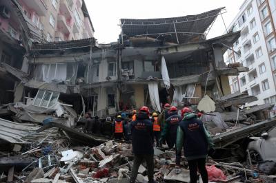
The commonality among the recent earthquakes in the region is that they occur at points which if connected by a line would outline the boundaries of the Arabian tectonic plate, which with its continuous movement towards the north, was the primary reason for the Kahramanmaraş earthquake that claimed more than 50,000 lives in Syria and Turkey, after colliding with the Anatolian plate at the Eastern Anatolian fault, causing a massive break in the ground that extended over 300 kilometers, affecting most of the surrounding seismic faults connected to it.
#### From Syria to Hiroshima
Syrian researcher Rasha Amer, who holds a PhD in sciences (seismology) from Hiroshima University in Japan, specializes in predicting large earthquakes through slow earthquake records at Hiroshima University (previously) and currently holds a research position in safe carbon dioxide storage to mitigate gas emissions and climate changes at the Advanced Earth Technologies Research Institute in Kyoto, Japan, summarizes what is occurring as follows: "They are natural phenomena, and nothing is beyond nature."
"Can an earthquake be predicted?" she firmly denies this because the earth is inherently chaotic, but "historically, an earthquake in Kahramanmaraş was predicted (in location but not timing) in a study conducted in 2002 by Turkish researcher Suleiman Nalbant."
Amer clarifies: "The study relied on analysis of Coulomb stress (the force of attraction or repulsion as per Coulomb's law) along the fault zone by analyzing 10 earthquakes and calculating the stresses resulting from them since 1822 (180 years) and assessing stress accumulation on a fault section in the Kahramanmaraş area. It clearly indicated stress accumulation in that area and recommended conducting detailed studies."
Why are earthquakes increasing? She responds: "In recent years, the number of earthquakes has increased - not because there are actually more earthquakes, but due to advancements and more seismic measuring instruments. Statistically, the National Earthquake Information Center records about 20,000 earthquakes worldwide every year, or nearly 55 earthquakes daily. It expects about 16 major earthquakes to occur each year, which includes 15 earthquakes in the range of 7 degrees and an earthquake of 8.0 or greater."
#### Why Did the Earthquake Occur in Turkey and Syria?
She explains: "The earthquake occurred in an area that serves as a triple junction where the Anatolian fault and the Dead Sea fault system or the Eastern Mediterranean fault and the Cyprus Arc system are linked, along with the main maritime fault extending in that region."
The destructive power of earthquakes does not depend solely on their magnitude, but also on the depth of the focus, she emphasizes: "The closer it is to the surface, the more destructive it is. After the 2011 Japan earthquake measuring 9.0, the aftershocks continued for years, with the last one occurring ten years after it."
#### The Middle East
Amer assures: "Seismic activity in the Middle East is classified as moderate to weak. Numerous earthquakes have occurred throughout history, but no large earthquakes have occurred in modern history, which means we have been living with seismic danger for hundreds of years and will continue to do so. This is the nature of our earth. The difference now is that the non-specialized public has become aware of this danger, whereas it was entirely ignorant of it before February 6."
She explains: "The Arabian plate in the Middle East is home to the countries of Kuwait, Bahrain, Qatar, the United Arab Emirates, Oman, Yemen, Saudi Arabia, Syria, Jordan, and Iraq. The Arabian plate separated from Africa about 25 million years ago, leading to the closure of the submerged Tethys Sea in the northeast, and the rift in Africa and the Arabian Peninsula opened the Red Sea and the Gulf of Aden at the plate's boundaries to the southwest and south, respectively."
She adds: "The average expansion rate of the Red Sea is about 10 mm per year, and the Gulf of Aden is believed to be a rift extending westwards at a rate of approximately 3 mm per year, while the Red Sea continues to open. Eventually, the Arabian plate collided with the Eurasian (Anatolian) plate, and this collision area was identified by the Zagros Mountains. This mountain range has a collision rate of 9 ± 3 mm/year in the southeast and 5 ± 3 mm/year in the northwest. The Dead Sea fault lies along the boundary of the Arabian plate to the west and has witnessed about 107 km of left lateral displacement since the mid-Miocene, translating to an approximate slip rate of 6-10 mm/year."
#### What About Volcanoes?
According to Amer, the Arabian plate hosts extensive basalt plateaus from the Paleolithic era, stretching parallel to the Red Sea, referred to as the Hararat. In total, they cover an area of 180,000 square kilometers and are linked to the rift in the Red Sea during the Oligocene epoch. The largest is the Ash Hararat - covering an area of 50,000 square kilometers with volcanic cones and shield volcanoes. Two periods of activity for this volcanic field have been identified: the first extending from the late Oligocene to the mid-Miocene, attributed to the Red Sea fault, and the second roughly 13 million years ago in response to the counterclockwise rotation of the Arabian plate.
She continues: "As for the Red Sea fault, it is a center of extension between the African and Arabian tectonic plates. The Red Sea fault extends from the Dead Sea fault system and ends at the intersection with the Aden protrusion and the East African fault, forming the Afar Triangle junction in the Afar Depression in the Horn of Africa. The Red Sea fault is located in Egypt. The fault region includes the island of Jabal al-Tair, formed by a basalt stratovolcano of the same name located northwest of Bab al-Mandab at the mouth of the Red Sea, midway between Yemen and Eritrea. The volcano erupted on September 30, 2007, after 124 years of dormancy."
Concerning volcanoes, she concludes: "In general, there are no indications of current volcanic activity, and volcanoes cannot be predicted as earthquakes can; we rely on preliminary indicators."
#### Data Processing
After the earthquake of February 6 and its tragedies, Amer sees a necessity in processing the actual seismic data in Syria and complementing it with displacements recorded from satellites, geological information, and existing models based on calculations of pressure changes (stress) resulting from these events to create a new seismic hazard map in Syria illustrating the area's status, pressure distributions, and the locations most likely to experience tremors.
#### Lebanese Faults
Tony Nimer, a researcher in seismology at the American University of Beirut, confirms that Lebanese faults have been active throughout history: "In Serghaya, an earthquake occurred in 1759 measuring 7.4, another occurred in Yamuna in 1202 measuring 7.5, and there is the maritime fault that caused a 7.2 magnitude earthquake in 551 AD followed by a tsunami, along with numerous other earthquakes whose awakening dates cannot be determined."
Nimer explains the fault that poses the greatest danger to Lebanon: "It is impossible to predict the size of an earthquake by merely looking at the latent pressure and earth factors and other data. In general, the Yamuna fault extends from south to north and thus is the longest, cutting through all of Lebanon, and if it moves entirely, it would produce a larger earthquake than that of the Serghaya fault, because the latter is indeed shorter than the Yamuna fault. The maritime fault is longer than both the Serghaya and Yamuna faults, and if it moves entirely, it can trigger a large earthquake in the Latakia range and between Cyprus exceeding 7.5 degrees. This occurred in the earthquake of 551 measuring 7.2, and its strength could surpass this figure, causing a destructive tsunami."
He points out that the "Dead Sea fault, which separates the Arabian plate from the African plate, runs through Lebanon via the Yamuna fault and branches into the Rashaya, Serghaya, and Roum faults. This means that Lebanon lies on the border of two plates. We mustn't forget the 365 AD earthquake that struck the Hellenic Arc south of Greece with a magnitude of 8.3, leaving a minor tsunami on Lebanon. In 551, an earthquake struck the Cypriot Arc measuring 7.2. The latter extends to the east towards the maritime Latakia range, and if it moves, it would have a strong impact on Lebanon."
#### Red Zones
Nimer rejects the notion of "red zones" and other safe areas, asserting that all of Lebanon is traversed by faults, but the destructive magnitude of an earthquake depends on the type of rocks, soil quality, and the resilience of buildings. He states: "In general, buildings constructed after the war are more resistant to tremors. If the rocks are solid and cohesive, they will resist earthquakes more effectively. For example, the downtown buildings and the port are earthquake-resistant because they were built after the war according to engineering standards that take this into account. The endurance will ultimately depend on the earthquake's strength."
#### 7.5 and Beyond...
And the final question: Is it possible for Lebanon to experience an earthquake exceeding 7.5 degrees? He nods positively, clarifying: "It is possible to exceed 7.5 in earthquakes if the Yamuna fault or the Latakia range in the sea shifts, but we won't say that what is coming will be a destructive earthquake, considering the likelihood that it may occur in two stages: that is, it may not exceed 6 degrees in the north or 6.2 in the south, relieving the earth's tension with less damage, and we would be fortunate."