


Calm may sometimes prevail at the Lebanese-Israeli border, but tensions soon return, particularly in the Shebaa Farms and the village of Ghajar, as Lebanon still considers that Israel occupies parts of its territory.
The Blue Line, which separates Lebanon from Israel, has witnessed significant tensions that have raised the issue of land border demarcation once again. Military and strategic expert Amin Hoteit stated that "the land borders in Lebanon are definitive, and there cannot be new borders." In an interview with "Warda," Hoteit mentioned: "The Blue Line is an imaginary line without any legal value; Lebanon and Israel have not signed an agreement on it; rather, it is a line created by the United Nations to verify the Israeli withdrawal." He further explained that "the Blue Line is divided into two parts. The first part extends from Naqoura in the west to the Metula in the east, parallel to the Wazzani River at Ghajar, with Lebanon reserving three points on this part with the United Nations." As for the second part, it starts from Ghajar to Hermon, where "Lebanon and the UN do not agree on the Blue Line—except in the area of Ghajar—where the borders coincide, and thus there is no dispute."
Hoteit stated: "The Blue Line in Shebaa differs from the international borders recognized by Lebanon, which extend from Ghajar northwards to Shebaa Valley and Hermon. The Blue Line proposed by the United Nations climbs from Ghajar to Hermon, deviating from the international border by varying distances depending on the terrain, leading to the creation of the Shebaa Farms. The UN acknowledges the Lebanese ownership of these farms but denies the operational authority for UNIFIL in them." He noted that "there is no buffer zone between Lebanon and Israel, so the Lebanese army can reach the border whenever it wishes, as can the Israeli army."
**The Blue Line**
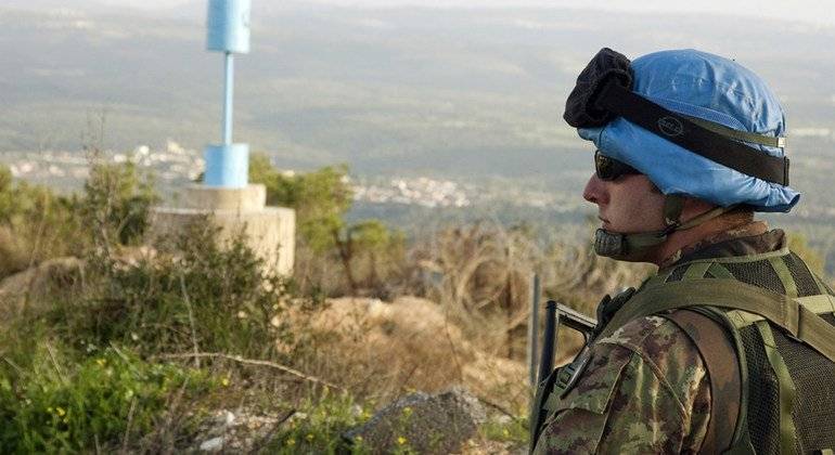
The Blue Line is the withdrawal line determined in 2000 by the United Nations, in cooperation with Lebanese and Israeli officials, aimed at confirming the withdrawal of the Israeli army from Lebanese territory, in accordance with UN Security Council Resolution 425 passed in 1978 following the first Israeli invasion of parts of southern Lebanon. The Blue Line stretches for 120 kilometers along southern Lebanon's borders, and during one of the tripartite meetings in 2007, both parties agreed to place visible markers along the Blue Line on the ground.
It's important to note that the Blue Line does not in any way represent an international border. The process of marking the Blue Line is an ongoing tripartite project between Lebanon, Israel, and UNIFIL to promote mutual trust and reduce tensions. The blue barrels, which are water markers placed along the Blue Line, aim to secure the safety of the populations living on both sides of the line by preventing any unintentional crossing.
After the 2006 war, the Blue Line became a central element of Resolution 1701. Since 2007, UNIFIL has worked with the parties to place the blue barrels that clarify the precise course of the Blue Line. Each of the 272 blue barrels currently marking the line was only placed after complex verification and agreement from both sides.
**Drawing the Blue Line**
The Blue Line was drawn in 2000 by the United Nations, through two completely separate committees: one Lebanese-UN composed of a Lebanese team of five members led by Brigadier General Amin Hoteit, and an international team of seven members headed by General Serinen, Deputy Commander of the international forces in the south (UNIFIL); and the second committee was Israeli-UN composed of an international team of five members also led by General Serinen, along with an Israeli team of six members. Each committee worked within its own scope, with the international team relaying positions and requests without any direct contact between the Israeli and Lebanese parties.
**Disputed Areas**
The initial proposal presented by the United Nations for the Blue Line varied from the international borders between Lebanon and occupied Palestine in 13 areas, totaling slightly over 18 million square meters. Lebanon rejected this line through its military committee chaired by Hoteit, and after bitter discussions lasting several days within the Lebanese-UN committee (which held its last session under the presidency of the then Lebanese President Emile Lahoud), the UN adapted its line based on feedback and retracted its proposal in 10 areas, holding onto three points: Rmeish, Adaysseh, and Metula. With Lebanon insisting on its rights to those areas, a solution was adopted that amended the international line in the 10 areas, while Lebanon reserved the rights to the three remaining areas, ensuring that the current situation on the ground remained as it was. This effectively prevented Israel from advancing into Adaysseh and Rmeish, leading to the notion of the three reservations.
**Reservation Points**
During the demarcation of the Blue Line, Lebanon reserved several points along the line, considering them Lebanese territories, while Israel regarded them as part of its land. These "reservation areas," according to the Lebanese concept, encompass 13 points extending over 114 kilometers, which is the total length of the Blue Line from Shebaa to Naqoura. Among the most significant of these points are the Shebaa Farms, Kfarshouba hills, the Lebanese part of the village of Ghajar, parts of the Metula settlement, Khallet al-Maafar in Adaysseh, Rmeish, and point B1 in Ras Naqoura, in addition to 10 smaller points along the border.
UNIFIL does not recognize Lebanon's classification of these points, considering that Israel has withdrawn along the Blue Line, and that the term "reservation" applies only to Lebanon. Thus, any movement by Israel in these points is not considered a violation of Resolution 1701 by UNIFIL, while it is considered a breach if Lebanese individuals enter these areas.
**The Technical Fence**
The technical fence is an electronically monitored barrier built by the Israeli army alongside the route taken by its patrols along the Blue Line. It aligns with the Blue Line in some areas and breaches it at various points. There are many areas along the Blue Line without a fence, allowing Israel to move beyond this technical barrier into the unoccupied zone that separates it from the Blue Line, bringing its forces into direct contact with civilians or the Lebanese army, creating potential for security slips or direct clashes.
