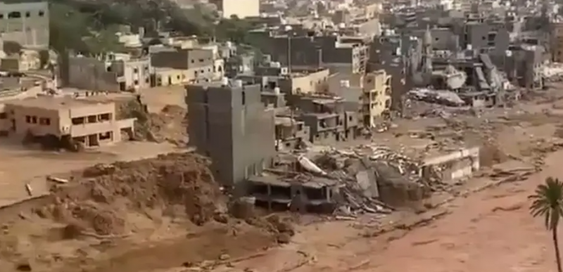
There are predictions that the number of missing persons due to Hurricane Daniel in Derna alone may exceed about 5,000 or 6,000 individuals, making it the most affected city in Libya. According to Qais Al-Fakhri, head of the Red Crescent in Benghazi, the valley that was 300 meters wide has now become 600 meters, while most buildings near the valley, including a residential building known as the "Assurance Building," have collapsed. The Libyan government appointed by the parliament announced that entire neighborhoods of Derna, which contain thousands of citizens, have disappeared into the sea. Where is this city that has been described after the hurricane as "what happened in the city is not a disaster but a catastrophe"?
Derna is a mountainous city located on the Mediterranean coast in northeastern Libya. It is bordered to the north by the Mediterranean Sea and to the south by a series of hills known as the Green Mountain. The city is split by a riverbed, known as Wadi Derna, which is one of the significant valleys in Libya; in 2011, Derna's population was around 200,000. It serves as the administrative center of the Derna municipality and is famous for its location and mountainous forests, which are nourished by fresh waters flowing through irrigation channels from two abundant springs, one known as Ain Al-Balad and the other as Ain Bou Mansour. The waters from the latter flow down from a high hill to the riverbed, forming what is known as the "shower" or "Bou Mansour Falls." Poets, both classical and modern, have praised the beauty of Derna and its flourishing greenery, its refreshing water, and its pleasant air, as well as the hospitality and gentleness of its people. Arab and foreign writers and tourists have spoken about its neighborhoods and monuments, with some referring to it as the "Bride of Libya" and the "Pearl of the Mediterranean."
Derna is connected to the town of Shahat by two roads: the first is the main internal road passing through Al-Qubah (part of the Libyan coastal road), and the second is the coastal road passing through the town of Bsoosah and Ras Al-Hilal.
**History**
Thanks to its geographic location, Derna has a rich historical background filled with events. During the Greek era, particularly in the Hellenistic period, the Greeks established four cities near Derna, which was called Erasa at that time. This city later joined these four, creating a kingdom of five flourishing cities known as PETAOS during that period.
During Roman and Byzantine rule, the city experienced stagnation and decline, which it soon overcame to play a vital role during the Ottoman era, particularly in the early 17th century under the rule of the Qurmanli family. Derna notably emerged during what became known as the Four-Year War, where it dominated both the city of Benghazi and the city of Al-Marj, the two major cities at that time. Derna remained an important administrative and commercial center during the Qurmanli family rule, thanks to its port and fertile agricultural lands, along with commercial, administrative, and cultural exchanges with the Maghreb and the Near East.
There are not many notable signs of the city’s emergence during the Italian occupation from 1911-1945, perhaps due to the relatively short occupation period and the view that the city was not as vital but rather a transit point, which did not help foster a distinct urban and cultural renaissance. Australian forces under British command managed to take control of Derna from the Italians on January 30, 1941, as part of the North African campaign. However, the Nazi Germans, who were allied with the Italians, regained the city from Allied forces on April 6, 1941, but the British managed to recapture it again in 1942.
After the Libyan revolution in 2011, several armed groups took advantage of the state of chaos, security breakdown, and the collapse of state authority, subsequently taking control of the city. Fighters belonging to the Islamic State (ISIS) seized parts of the city in 2014, but the Shura Council of Mujahideen in Derna managed to defeat ISIS and take control of the town in 2015.
**Climate**
Derna's climate is classified as semi-arid (according to the Köppen climate classification), with an annual average rainfall of approximately 252 mm. Winter temperatures range from 9 to 20 degrees Celsius. Average annual rainfall is moderate from October to March. The summer months are long with high temperatures, often exceeding 27 degrees Celsius from June to October.
**Affected Areas**
The Presidential Council in Libya declared Derna, Shahat, and Al-Bayda in the eastern region as disaster-stricken areas due to the floods that have swept through them. The statement read, "In light of our responsibilities and the serious repercussions of the disaster, we declare this area a disaster zone and request assistance and support from brotherly and friendly countries and international organizations."


